
Making your own weather forecast.
Key points covered:
Where and how to get a solid view of the overall weather in your area.
Drilling into wind for a specific location and time..
Overview of commonly used models.
How to handle an offshore passages.
Using a professional service
Being on the water means being exposed to the weather, that’s one of the beautiful things about being on boats, you are out in nature. Naturally we are going to be more interested in what the weather is going to be than if we were holed up inside all day (writing blog posts?). For me personally being on the water means racing sailboats or being out cruising New England in my 35 foot Downeast powerboat. Whatever the activity, I take the time to research what the conditions are going to be. Depending on the activity and how long I am going to be at it I will look at different things from which to draw my conclusions.
For example if I am racing a one design regatta I want to know hour by hour what the wind is going to be doing both in terms of strength and direction. I want a good sense of how accurate the forecast I am looking at so I can factor that into my tactics for the day. If I am sailing a longer event I want a good idea of what the wind will be from day to day so I can pick what sails to have declared to the organizer.
If I am taking my powerboat from its home base out on the elbow of Cape Cod to Martha’s Vineyard for the weekend I want to know the general weather (is it going to rain?) and a good general idea of from where and how hard the wind is going to blow. Powerboats the size of mine generally are uncomfortable pounding into strong headwinds and are squirelly with big following seas so I look at the trends over a few days around the dates my wife and I have selected from our trip. If it’s going to be really windy on the day we had planned to leave we might adjust and leave a day earlier or later. If it’s going to be rainy and blowy all weekend we might reschedule.
Today there are more sources of information on the weather than ever before and it can be overwhelming in terms of deciding what to look at and what to trust.
Start with NOAA first:
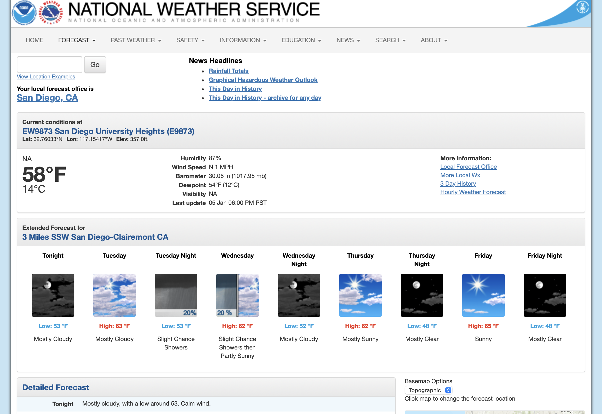
For whatever I am doing I like to get a good overview of what the general weather is going to be. At the beginning stage I simply want to know the basics but also gain a general understanding of what the present weather system is and what is coming up. For that I head to the basic NOAA website for an overview. Here I can get a general forecast for the next few days for my area of interest, if there is significant weather coming I will know it right away.
Go to weather.gov>type in your zip code>detailed information to get to this page. This give a nice overview of the general weather coming up.
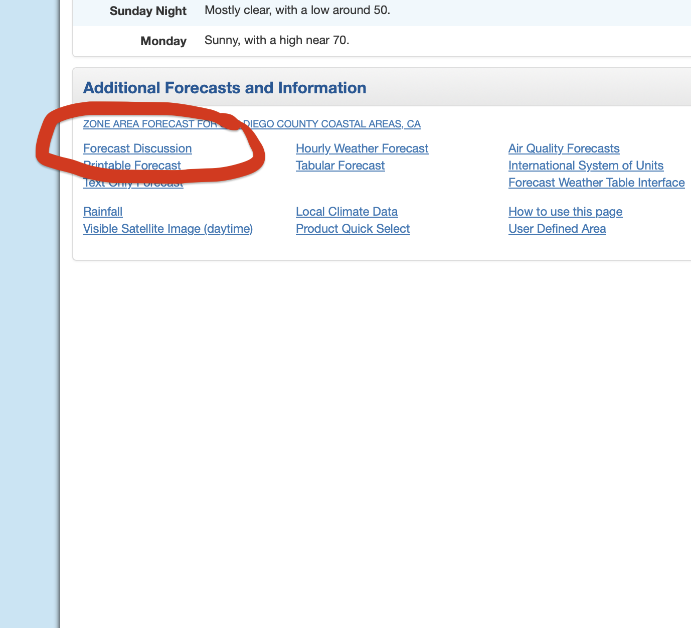
Once I have an idea of the very general weather I like to get a feel for what’s behind the weather we will be getting. For that scroll down to the bottom of the same page and look for “forecast discussion”. Here the pros at NOAA give a good overview of the upcoming systems and include a marine update. These are written by a real human and they also give a feel for how confident they are in their forecast. This discussion is often as good or better than what you get from paid services.
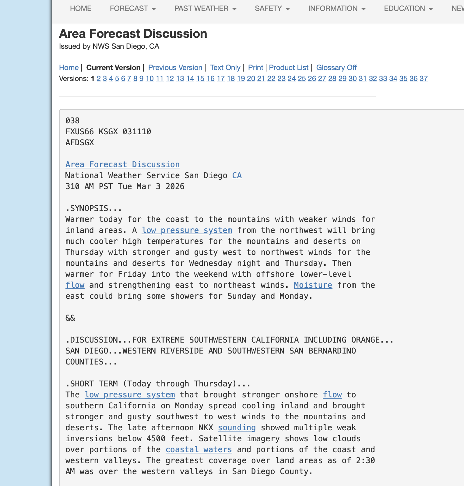
Here is an excerpt from the “Forecast discussion” for San Diego, effective 3:10 AM March 3rd 2026. Note: these are updated about every 6 hours by the local NOAA office.
The next step is to get a more accurate idea of the wind. For that I like to go to Windy.com. This site does a nice job of aggregating multiple models from around the world and displays them in the form of wind maps of any part of the globe You can zoom in right to the level of a decent sized one design race course and scroll over the time you will be on the water. The trick is knowing what each model is good at and then comparing each model’s forecast. I like to see how consistent the results are. From that I can be more or less confident in what they are predicting.
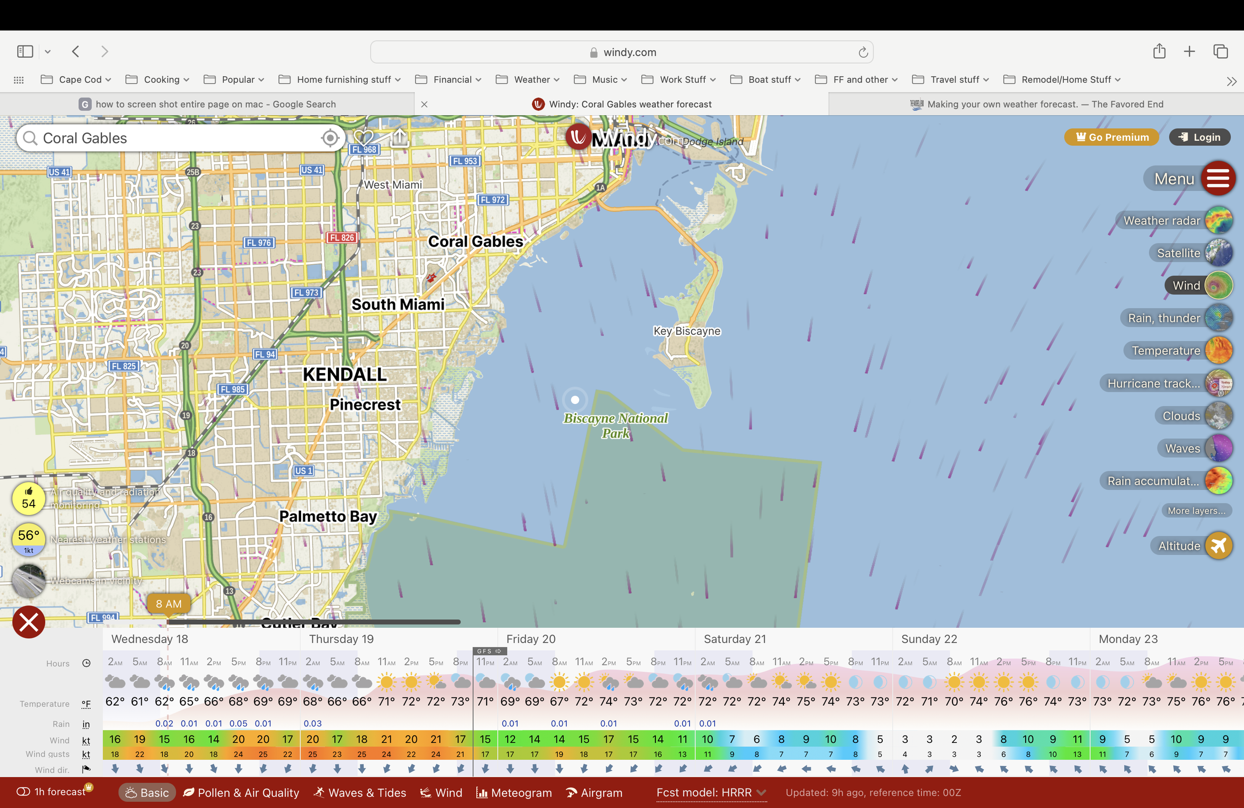
Screenshot of Biscanye Bay wind forecast from Windy.com. Model selected is HRRR which goes out for 48 hours. However it is most accurate for the next 18 hours. Forecast is for where the white dot is positioned. Note that GFS Forecast takes over after 48 hours.
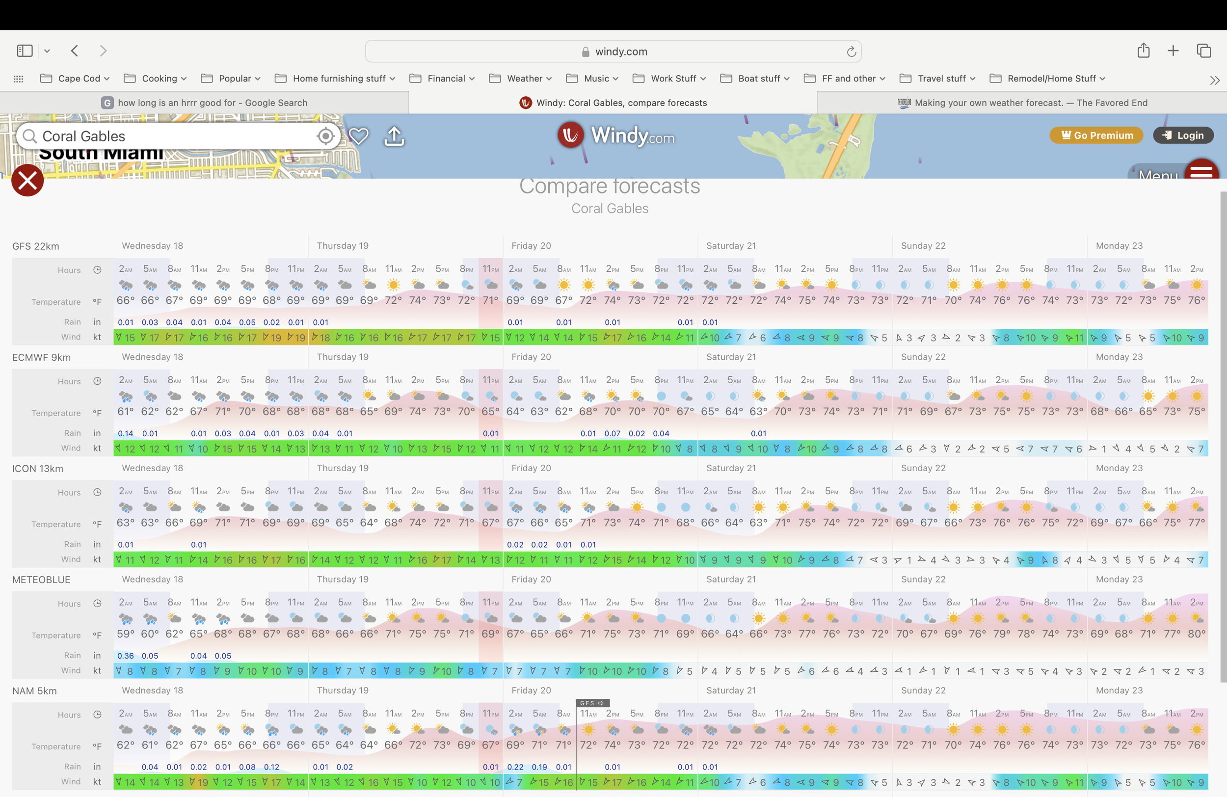
Forecast for same location comparing different models to get a better feel for what is really going to happen.
The US and many countries around the world have government meteorological services that not only provide local forecast but develop numerical models to forecast the weather. In the last 20 years with growing computer power and more sophisticated modeling these models have become quite accurate. Not fool proof but pretty darn good. Weather forecasting is big business. Agriculture, shipping, insurance and many other industries benefit hugely from accurate short and long range forecasts. It is important to have a basic understanding of the differences between the main models (see below).
Overview of main major models:
HRRR (High Resolution Rapid Refresh), This is the model I use primarily for one design sailboat racing and coastal cruising. The model is used for short term highly accurate forecasting. It provides wind and weather forecasts for every hour out for 18 hours. It is most accurate for the next few hours after it is updated, which is hourly. Note that the HRRR is only available in coastal regions (not offshore). It also only works in coastal regions of the USA, southern Canada and northern Mexico.
The HRRR is high resolution in that the grid size for its forecast is 3km. There are some sites the purport to do 1 km resolution but these are usually interpolations. There are some area where there are experimental 1km resolutions available.
The HRRR is special in that it also takes into account land features and how they affect wind speed and direction (as well as weather). This makes it especially useful for sailboat racing but also increases it overall accuracy.
While not perfect the HRRR is by far the best model for short term wind and weather forecasting close to shore and in the US.
NAM (North American Mesoscale), The NAM, like the HRRR is also a NOAA model. The NAM looks out at a longer window of time (84 hours, 3.5 days). Rather than being update every hour it update 4 times per day. Use the NAM to get a good idea of what the weather will be for next few days.
Like the HRRR the NAM takes into account topography to dial in its forecasts. As it name suggests it is primarily and North American based model. It is not a global model. It is excellent for medium term trends, note that it has a smaller resolution than the HRRR and uses a 12km grid.
ECMWF (European Center for Medium Range Weather Forecasts), The Euro model is a true global weather and regarded as one of the best a longer range forecasting out 10-15 days. Covering the globe, it has a resolution of 9Km and updates twice per day. It factors in the movement of the jet stream, ocean currents and more to create an accurate forecast. This would be a good one to look at when planning a longer ocean race or extended cruising. All the major weather sites incorporate the ECMWF.
Planning offshore passages:
Being offshore for days at a time requires significant planning and research. While it is now possible have great connection to the internet via Starlink, getting in trouble offshore is serious business and demands much more vigilance and planning. There are a few really good “routing” software packages. The one I like the most is Expedition (www.expedtionmarine.com). It is widely used by the world's best offshore sailors for racing and cruising. If you are serious about spending lots of time offshore I highly recommend getting a copy and learning the software.
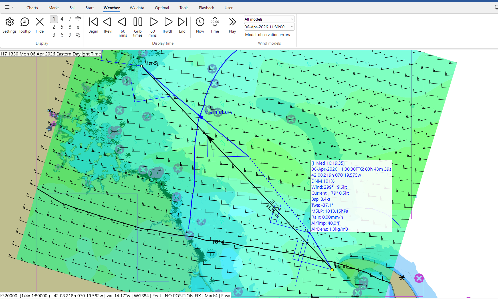
Sample of a short sailing passage from Provincetown MA to Marblehead using Expedition. Shading show wind speeds and is advanced in the steps the weather model is set to. Blue line is optimal route. Running cursor over route shows step along route with predicted boat speed, wind speed/direction, time to go and more.
Planning an offshore passage involves gaining a very good knowledge of the weather along your route, anticipated speed and route of travel. Simply picking the day to depart can be a good challenge. Because of that it can be a good idea to bring in the professionals and hire a dedicated weather routing company to help. One that I have used and who have done a good job is WRI (Weather Routing Inc). For a fee they will help you plan your passgage. Give them information about starting points, destination, average speed of your vessel and they will do the work for you. You can also tell them that you want to stay below a particular windspeed or sea state. Additionally they can send you updates by e-mail and track your progress providing updated routing along the way. I have found services like this to be a real stress reliever, it like adding a partner on shore who is also watching the weather for you.
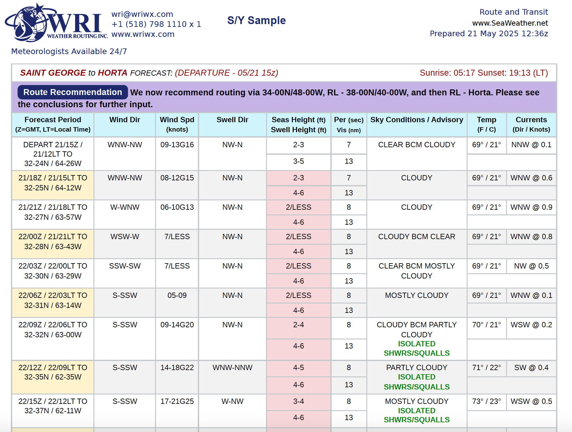
Sample route forecast showing conditions every three hours along route from WRI Inc. Courtesy WRI.
The weather is always in control when we are on or near the water. Whether heading out for a day of sailboat racing nearshore or planning and offshore passage in a powerboat the more your know ahead of time the better outcome you will have. By learning about the resources available to you and their strengths and weaknesses you will much more prepared for whatever Mother Nature sends your way.